
 |
||
| Scientists' Contributions | ||
SYSTEM FOR WATER MONITORING AND SUSTAINABLE MANAGEMENT BASED ON GROUND STATION AND SATELLITE IMAGES
Saso Manasov,
Enterprise for Physical and Urban Plans of the R. Macedonia (JPPUP),
Email: smanasov@unet.com.mk
Participants: Republic of Macedonia, Germany, Italy, Bulgaria, Greece and Prof. G.Knight (USA).
The aim of project is to model Struma River, transboundary river of Greece, Bulgaria and Macedonia, with create general mathematical and spatial (geographical) model (and development of numerical software) for water monitoring (water quality parameters measurements) and satellite images.
GSM (the transfer of data through mobile telephones) technology for data transmission and collection, for the purpose this project was introduced. A solution for data transfer through GSM was implemented and ORACLE database management system was incorporated. On one hand, we have monitoring and system configuration (flexible system: number and type of parameters, different locations, acquisition interval) in real time. Each quantity has unique: code, name and appropriate unit. It’s important to emphasize that this is an open system, without any restriction about the number of measurement quantities.
Digital map (Digital Terrain Model-DTM) for the Struma River basin is produced from satellite images with resolution of 20 and 50 meters. DTM is in Gaus-Krueger projection. Integration of these data is done in the Greek projection (Transverse Mercator, Ellipsoid GRS 1980).
The Struma River has got an extensive hydrological basin. At Sidirokastro Bridge of Struma River in Greece there is a station of discharge and water quality parameters are measured. In planning control and management program of streams, the analysis of the existing streamflow and water quality data is an important step for forecasting streamflow and future variation of concentration and load of pollutants.
The aim of this project also is to model Struma River using the Saint-Venant equations with the equations for sediment transport and the advection diffusion-reaction equations. Estimating the flows of rivers (or streams) can have significant economocal as well as ecological and social impact since it can help in agricultural water management and in protection from water shortages and possible flood damages. Spatial models useful for qualitative assessment of the existing conditions and the impact of the environmental change on runoff, availability and quality of waters has grown rapidly.
Results of the global climate change scenarios for the Struma basin, creation of GIS coverages for the Struma basin, neural network models for multispectral classification, snow cover monitoring with remote sensing, also was studied in this project.
DEVELOPMENT OF DATA BASE FOR RIVER STRUMA BASIN
Participants: Germany, Italy, Bulgaria, Greece, R.Macedonia and Prof. G. Knight(USA).
For the purpose of development of the data base regarding the river Struma basin, research of the results obtained by several different projects, related to the hydro-meteorological and geographical data useful for water monitoring systems, was undertaken. The collection of geographical, meteorological and hydrological data for creation of the system data base, was done in co-operation with Hydro-meteorological Institute of Republic of Macedonia (HMI) and Enterprise for Physical and Urban Plans of the R. Macedonia (JPPUP). Large amount of necessary data are already acquired and classified and is partially incorporated in the data base system.
CREATION OF ARC/INFO BASIC COVERAGE FOR RIVER STRUMA BASIN ON THE SCALE 1:100 000
Participant: Sasho Manasov, M.Sc., Republic of Macedonia.
Digital map (digital terrain model) for the part of the river Struma basin in R. Macedonia – the river Strumica coverage (including its all tributaries) was created in GIS environment with resolution 20 m by JPPUP-Macedonia. The model was produced using SPOT satellite images taken during the year 1995. The digital terrain model was given in Gauss-Krueger projection with unknown geodetic date, which represents the minimum set of parameters necessary to define the location and orientation of the local system with respect to the reference system. Integration of these data with the digital terrain models of Greece and Bulgaria, which were with resolution of 100 m and 50 m respectively, was performed in the Transverse Mercator projection, Ellipsoid: GRS 1980, Datum: D_GGRS_1987, which is in due practice in Greece. By this way all digital models were reduced to the same projection but with different geodetic date. The derivation of translation and rotation parameters was done through identification of selected points which are the same in the different systems. The complete digital terrain model, covering all parts of the river Struma basin (in R. Macedonia, Bulgaria and Greece), with resolution of 50 m, was achieved at the expense of degradation of the available digital terrain model for the macedonian part of the Struma river basin from 20 m to 50 m.
DEVELOPMENT OF THE DETAILED HARDWARE MODEL FOR DATA TRANSMISSION IN THE GSM SYSTEM. SPECIFICATION OF DATA FORMAT.
Participants: Jani Macraduli, M.Sc. and Sasho Manasov M.Sc., Republic of Macedonia.
In 1982 at the Conference of European Posts and Telegraphs (CEPT) was formed a study group, called the “Groupe Special Mobile (GSM)”, to develop a pan-European public land mobile system and to overcome equipment and operation incompatibilities among different developers. The proposed system had to meet certain criteria such as:
good subjective speech quality, low terminal and service cost, support for international roaming, ability to support handheld terminals, support for range of new services and facilities, spectral efficiency and ISDN compatibility.
The generic GSM network architecture is composed of several functional entities, with specified functions and interfaces depicted in the figure. Three broad parts: Mobile Station, Base Station Subsystem and Network Subsystem can be recognised.
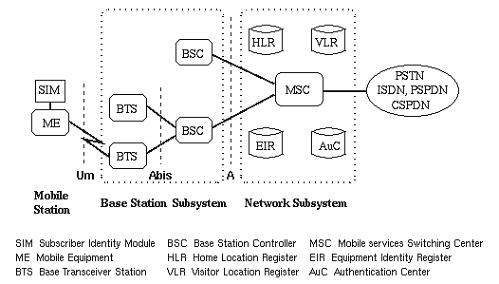
The Mobile Station (MS) is located at the subscriber's site, while the Base Station Subsystem (BSS) controls the radio link with the Mobile Station. The Network Subsystem, performs the switching of calls between the mobile users, and between mobile and fixed network users. The key element within Network subsystem is the Mobile Services Switching Center (MSC). The MSC also handles the mobility management operations. The MS and the BSS communicate across the Um interface, also known as the air interface or radio link. The BSS communicates with the Mobile Services Switching Center across the A interface.
- The Mobile Station comprises a cellular phone-set (the terminal) and a smart card called Subscriber Identity Module (SIM). The SIM provides personal authentication, so that the user can have access to subscribed services irrespective of a specific terminal.
- The Base Station Subsystem is composed of two parts: the Base Transceiver Station (BTS) and the Base Station Controller (BSC). These communicate across the standardized Abis interface, allowing (as in the rest of the system) operation between components made by different suppliers. The BSC manages the radio resources for one or more BTS’s. It handles radio-channel setup, frequency hopping, and handovers, as described below.
- The central component of the Network Subsystem is the MSC. It acts like a normal switching node of the PSTN or ISDN, and additionally provides all the functionality needed to handle a mobile subscriber, such a registration, authentication, location, updating and call routing to a roaming subscriber. The MSC provides the connection to the fixed networks (such as the PSTN or ISDN). It is important to emphasize that the signalling within Network subsystem is SS7 (Signalling System 7).
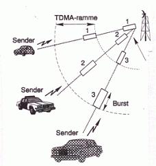
Since radio spectrum is a limited resource shared among all users, GSM introduced the method for splitting the bandwidth among as many users as possible. The method is a combination of Time and Frequency Division Multiple Access (TDMA/FDMA). The FDMA part involves the division by frequency of the (maximum) 25 MHz bandwidth into 124 carrier frequencies spaced 200 kHz apart. One or more carrier frequencies are assigned to each base station. Each of these carrier frequencies is then divided in time, using TDMA scheme, into 8 logical channels. A TDMA frame contains one time-frame from each of the eight channels, and lasts 04.615 ms.
The International Telecommunication Union, which manages the international allocation of radio spectrum, allocated the bands 890-915 MHz for the uplink (mobile station to base station) and 935-960 MHz for the downlink (base station to mobile station) for mobile networks in Europe.
GSM SOLUTION FOR DATA TRANSFER.
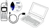
In these days several communication problems exist, among them is the transfer of data completely without PSTN (Public Switch Telephone Network) support. Waterman?? (What is the abbreviation for the Project ?) project involves the case in witch bi-directional communication is required, with one point impossible to be connected to PSTN, namely the measuring station point. Only few companies provide a solution for this kind of transfer, some of them are Ericsson, Compaq and Siemens. Our experience is close to NOKIA products, the Nokia Data Suite 3.0, offering several technical performances such as:
- Compatible with GSM900/GSM1800 mobile phones with serial cable
- 9-pin RS232C DAU-9P
- Data speed up to 14,400 bps
- Windows 95/98/NT 4.0
- Dual-up, HyperTerminal
- ProComm Plus 32, PcANYWHERE32
The data transferred through GSM will be managed in the Oracle database platform and this gives another positive performance to the previous choice. Oracle8i database system delivers unprecedented ease-of-use, power, and price/performance for workgroup or department-level applications. It includes also a fully integrated set of easy-to-use management tools, full distribution, replication and web features. From single-server environments to highly distribute, branch environments, Oracle8i includes all the facilities to build business-critical application.
IMPLEMENTATION.
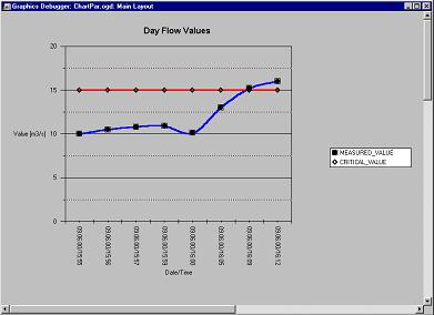
For the problem outlined, a hardware implementation of connection between a mobile handset and a PC was realised and the software application support for the interface was tested. The software design was split between client and server side. On one hand we have acquisition, and on the other we have monitoring and system configuration. Within the system configuration, flexibility for modifying the parameters, i.e. time slot changing or adding/dropping monitoring parameters, is available. Upon finishing the monitoring process, this kind of application offers an opportunity for creating various type of reports, for example: graphical or textual reports and reports in GIS environment.
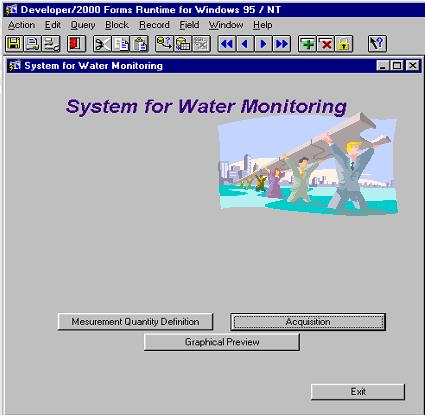
On the server side, the front panel offers several options such as: measurement quantity definition, data acquisition setup and graphical preview.
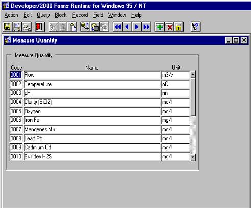
In measurement quantity definition window it is possible to include a new parameter or to modify an existing one. In this window each parameter observed has its unique code, name and appropriate unit. It is important to emphasise that this is an open system, without any restriction about the number of measurement quantities.
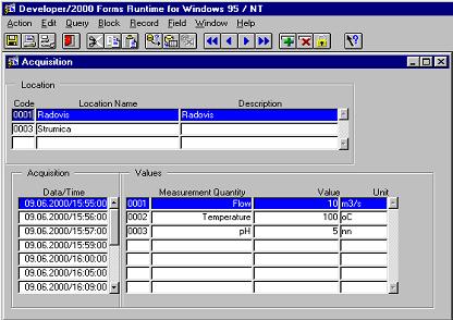
The Acquisition window is shown in the following figure:
INSTEAD OF CONCLUSION.
GSM technology for data transmission and collection, for the purpose of this project, was introduced. A solution for data transfer through GSM was implemented and Oracle database environment was incorporated. Such approach offers:
- Reliable transfer of data from client to server side via GSM and introduction of Oracle database management system
- Flexible system configuration: number & type of parameters, location or acquisition interval
| Back to the top |
 |
||
| Scientists' Contributions | ||