
 |
||
| Scientists' Contributions | ||
Meteorological Challenges in Urban Air Pollution
By D R Middleton
Met Office London Road Bracknell Berkshire RG12 2SZ
&a134; Crown Copyright Met Office 2002
Email: doug.middleton@metoffice.com
-
Contents of the document
Abstract
The European Action called COST is an international programme of co-operation in science and technology. This paper considers the work of COST 715, Meteorology Applied to Urban Air Pollution Problems. It is a request for information concerning meteorological observations in or near urban areas. Readers from local authorities, universities, or other organisations, are invited to complete the electronic questionnaire. The results will be assembled into a European data base of urban meteorological observing stations. The work of COST 715 will be of especial interest to users of dispersion models. It is leading to new recommendations on how airport meteorological data should be adapted for urban modelling, and on how urban meteorology should be observed routinely for managing air quality. Web sites are given.
1. Introduction
Following the London Smog of December 1952, when some »4000 excess deaths occurred, and the ensuing investigations of the Beaver Committee, the Clean Air Act was passed in 1956. This introduced Smoke Control areas. In December 1991, long after local use of coal had been largely eliminated across London, a severe episode of nitrogen dioxide was recorded. This also exhibited excess deaths, albeit a smaller number of »160. When the Bill to create the Environment Agency was passing through Parliament, the House of Lords with NSCA assistance, proposed and successfully saw Part IV added to the Bill, so that local air quality management as we see it today became a statutory duty under the Environment Act 1995.
The Met Office has long been involved in advising on meteorological conditions during periods of high air pollution, and since the Chernobyl disaster, its work on dispersion of materials in the atmosphere gained renewed importance. The NAME model has come from this work and is now the UK's most advanced dispersion model for long range atmospheric pollution. It has recently been adapted for forecasting air quality in the national Air Quality Bulletins. In its role as the national Meteorological Service for the UK, the Met Office was asked to provide a representative on the COST 715 Action. This Action is particularly appropriate, in that following its earlier work on the Aeolius model for street canyons (Buckland, 1998; Buckland and Middleton, 1999; Middleton, 1999; Manning et al., 2000), the Office had been conducting field experiments in Birmingham (Ellis and Middleton, 2000a; 2000b). The measurements of urban meteorology in 1998, 1999, and 2000, were designed to improve our understanding of how urban effects might be included when modelling air quality. This was a research question of some importance, for a number of local authorities had sought advice from the Office regarding meteorological data and observations in urban areas. It had also become clear from work on the forecasting of urban air quality using the Boxurb model, that a proper diagnosis of the heat flux and atmospheric stability was needed in cities (Middleton, 1998). At the time of the Environment Act in 1995 and the launch of local air quality management, there were gaps in the scientific knowledge of urban meteorology. They needed addressing in order to answer questions of practical import. This paper summarises some key ideas on how meteorological data are used for dispersion models. It then outlines some notable achievements from the COST programme, followed by the four topics being studied by the Working Groups that make up COST 715. This paper ends with a request for help in completing the survey of urban meteorological observing stations.
2. Urban Met Data in Dispersion Models
In urban areas, the wind over increased surface roughness creates greater mechanical turbulence. Stability is influenced by the urban heat island and its effect on thermally induced turbulence, which may lead to a delay in the onset of the evening transition to night time stable conditions (Middleton, 1998). In the case of a large city these effects can lead to an almost complete absence of stable conditions, which would be present in the surrounding rural areas (Oke 1987), and this will have an effect on air quality. A large urban heat island may generate local mesoscale flows, changing wind speeds and directions over the city.
However, the parameterisation of urban meteorology is not well understood. In order to develop urban dispersion models this must be remedied, particularly the diagnosis of stability over a town or city. Observations and physical models play a large part in developing the understanding upon which numerical models are built.
Figure 1 illustrates the factors to be considered when describing urban meteorology: Meteorological pre-processors (Middleton, 2001) use the input data to distinguish convective situations ( H>0 ; L<0 ) from stable situations ( H<0 ; L>0 ), where L is a measure of the stability, usually assumed uniform across a city. Cities change z0 and u*, but also need modifications (Middleton et al., 2000) to amend H and L (which is rarely done in current models). The city may be biased towards when compared with an airport or rural synoptic meteorological station. The stability L may have a limiting value in a model to prevent a model city atmosphere becoming too stable, but to what should this limit be set? If the temperature stratification is multi-layered, what should h be? These are the sorts of question for which current work in urban meteorology seeks answers. It requires a mixture of large scale urban experiments, small scale physical wind-tunnel modelling, and work to develop new parameterizations and to validate numerical modelling.
3. An Overview of COST
Co-operation in Science and Technology across Europe has a long and distinguished history, and many topics have been studied. COST is 30 years old and was reviewed by Joffre (2001): the present articles draws upon his review (and personal communication). COST is an agreement between nations in Europe. It is managed by a Technical Committee; Sylvain Joffre from the Finnish Met Service Chairs the COST Technical Committee for Meteorology, and serves with COST 715. This means that meteorological topics, including air pollution, are well covered within COST. The 700 series of Actions cover Meteorology in its many guises; currently eight are active. Actions run for a period and then finish, usually culminating in a final report with recommendations. The COST Action supports meetings, study contracts, visiting experts, short term scientific missions and reports. COST serves to develop ideas and promotes science through bringing experts together from different countries. By interchanging ideas on a subject and future directions for research it can have a significant impact on European science. It can lead to the writing of research proposals, often involving institutes from several countries as joint partners. COST itself does not fund research work, yet by facilitating co-operation it has led to some notable achievements. These include:
Ultimately, developments which lead to improved numerical weather forecasts enable better air quality forecasts to be made. Dispersion models such as the Met Office NAME model rely very heavily on having the best possible predictions of the evolving weather fields. The air quality community is dependent in part upon the advancing science of meteorology. In addition to improving the basic science, there is also a role for the COST Action 715 that looks specifically at meteorological data for urban pollution. Urban air quality cannot be properly managed without due consideration of the use and suitability of meteorological data and its pre-processing within a city environment. Similarly, secondary pollutants such as particles and ozone are formed and removed during long range transport, so mesoscale meteorology becomes important for their control.
Some 20 countries across Europe have therefore signed up to the COST715 Action on Meteorology Applied to Urban Air Pollution Problems. The Chair of the Management Committee is Professor Bernard Fisher, and the author is the second UK representative. Ranjeet Sokhi at the University of Hertfordshire is a member of the Working Group looking at episodes. The aim of COST 715 is: To improve the use of meteorology in understanding, modelling and managing air pollution, especially in urban areas.
It has a Management Committee (B Fisher) and Working Groups:
The author as UK representative hereby asks all local authorities, and other institutes such as Universities, who conduct urban or near urban meteorological observations, to provide information to the COST 715 urban station survey (web site at end of this paper for electronic submission of your information please). The Met Office will provide its summary of the urban stations that it supports. When complete, this survey represents an opportunity to see how meteorological information is gathered across Europe for dispersion modelling in environmental impact analyses and local air quality management. Decisions on whether or not to declare an air quality management area can be sensitive to meteorological data. Along with emissions, meteorology plays a significant part in contributing to the overall uncertainty of urban dispersion modelling. COST 715 is seeking an improved understanding in this subject. By completing the survey, readers can contribute in a very positive way to this work. It will be valuable to know about the measurements, how the data are processed, and what they are used for, such as direct input into a dispersion model. For example, the Airviro dispersion model uses a local urban site to obtain wind and stability data. When readers have tried the electronic survey, they should contact the author with any comments or suggestions, to be reported back to the COST Management Committee.
The station survey covers measurement. As hinted at earlier, numerical weather prediction models play an increasingly important role in describing meteorological situations as they evolve in time and space. COST 715 is also looking at how such models may be adapted to take account of the urban surface as their lower boundary condition. COST 715 also examines how the outputs of weather models might be post-processed to include urban effects and render the data suitable for input to a dispersion model.
4. Urban Experiments
Measurements in urban areas are designed to identify ways in which local meteorology may be changed by a conurbation. It is well known that urban areas have several effects:
One direct consequence is the greatly increased complexity of trying to define a good location in height and position for meteorological instrumentation in a city. Typically, a mast might need to be twice building height or more, but in some cities this can become impractical. It also means that when sensors are placed high above the surface, they 'see' a different surface according to wind fetch. Also, as the wind speed varies, the region on the surface that influence the sensor may also change, because properties like heat, momentum, or water vapour must diffuse upwards in order to reach the sensor, but at the same time these properties are advected horizontally by the wind. An important design feature of urban measurements should therefore be the parallel operation of a reference station outside the city, so that the data can be related to and compared with the more normal standard observations. There is therefore scope to apply remote sensing techniques, such as lidar (Vaughan and Forrester, 1989; Constant et al., 1989) or sodar, in order to gain information from heights and locations not attainable via masts. It is also necessary to compare the results of urban experiments with the predictions of numerical weather models, to find ways to improve the modelling of local effects. Such experiments are complex to design. They require intensive instrumentation and considerable resources. The data can take some years to analyse and report. COST 715 has been reviewing urban winds (Rotach et al., 2001; Soriano et al., 2000) and heat fluxes (Middleton et al. 2000).
4.1 Birmingham, UK
The purpose of this study is to increase our understanding of urban meteorology, with the ultimate aim of providing an improved assessment of urban boundary layer stability, which could lead to better air quality forecasts. It is also important to have measured values for the roughness length z0 in UK cities. This is an important variable for dispersion models. Martano (2000) had suggested a scheme to obtain surface roughness length z0 from a single ultrasonic anemometer, whilst Grimmond et al. (1998) had also discussed the derivation of aerodynamic roughness for urban areas. They cited an earlier review of 50 studies that estimated z0 from different methods.
Measurement campaigns were conducted in Birmingham, UK, during April/May 1998, January/February 1999, and July/August 2000. The location was Dunlop Tyres Ltd., a large tyre factory. Standard meteorological observations were also taken 8.5 km away from the Met Office station at Coleshill, just outside the city. Instrumented masts of 15 m, 30 m, and 45 m were set up, secured by guy ropes. At these heights, measurements were taken of turbulence, wind and temperature. Derived from these were sensible heat flux, friction velocity, roughness length and Monin Obukhov length. Short-wave and long-wave radiation, pressure, rainfall and humidity were also measured. Since the exchange of heat between atmosphere and underlying surface is important, temperatures were also measured at 2 m above the surface, on the surface (grass or concrete) and down to 1 m below the surface. Results from the first two trials were described by Ellis and Middleton (2000a, 2000b). The urban temperature was ~1°C greater than the rural temperature, with some lag. Rooney (2001) has shown the roughness length was in the range 0-2 m, fairly typical of values used in dispersion models for cities, with uncertainty of circa ± 1 m. He analysed the effects of wind direction, according to fetch and land-use type. The 2000 trial is being analysed; it had the addition of a sonic anemometer at 15 m at Coleshill, so the heat flux and turbulence can be compared at the rural and city sites. It was noticeable that the urban heat flux was much nearer to zero overnight than at the rural site. These results are being used to investigate ways of improving the diagnosis of atmospheric stability; they have shown deficiencies in modelling the early morning transition.
4.2 BUBBLE, Basel, Switzerland
The Basel urban boundary layer experiment (Bubble) measures the turbulence and energy balance in the flow over the city Rotach, personal communication). The aim is to take measurements continuously for 1 year, over 2001-2. The instrumentation includes several 30 m towers with ultrasonic anemometers, and remote sensing equipment (profiler, lidar and sodar). A tethersonde or tethered balloon will also be used to lift instruments well above the surface. Model studies include urban parameterization in mesoscale modelling, and dispersion studies using Eulerian (grid-based solving of advection and dispersion) and Lagrangian (particle random walk) models.
4.3 ESCOMPTE, Marseille, France
The region around Marseille in Southern France emits » 25% of volatile organic compounds in the whole country. It has winds influenced by the land-sea breeze system with the Mediterranean, and winds coming down the valley to the city. There is a significant photochemical pollution problem. ESCOMPTE was set up to measure validation data for numerical models of pollutant transport and chemical reactions (Mestayer, personal communication). The aim was to build a data-base of emissions inventory, meteorological observations, and air pollutant concentrations. Equipment includes aircraft, a ferry, remote sensing, constant density balloons, and the surface sites The scale of this experiment is appreciated from the planning timescale:
This represents a major and well planned attempt to obtain the type of comprehensive data set over a large city that modern air quality modelling requires for its development and validation.
4.4. Radio Tower Data: Hamburg, Germany; Helsinki, Finland
Radio towers meet the criterion that they can be many times average building height. They are therefore very useful platforms for mounting anemometers and thermometers. However care is needed to position the sensors as far out from the structure as possible, and to select data when the wind is approaching the sensor directly and is not in the lee of the structure.
The Hamburg radio tower is 300 m tall, with measurements at 6 levels from 50 m to 280 m. There is an arm at each platform to hold the sensors away from the tower. Using an ultrasonic anemometer the wind components are sampled 10 times per second, whence 2´1014 samples, or 27.3 minutes, is sufficient to calculate turbulence spectra and other quantities such as turbulent length-scales. These were used in the new wind tunnel to ensure proper scaling of flow over a 1:400 (by size) urban model (Schatzmann, personal communication).
The Helsinki (Kivenlahti) radio tower has measurements up to 327 m. Data have been recorded continuously from 1989 till the present. The observed wind profiles can be influenced by the presence of the mast. However the data are very valuable when analysing severe inversion conditions leading to pollution episodes in the city of Helsinki (Karppinen, personal communication). Temperature measurements enable the calculated temperatures from numerical weather prediction models (such as HIRLAM) to be validated. From 27-29 December 1995, such an episode occurred. The tower data showed the temperature inversion was reaching 18 C at its worst on the 28th. This is a much stronger temperature inversion than the severe NO2 episode in London on 13th December 1991, when the Crawley ascent suggested the inversion in the lowest layer was of order 5 C.
The proper modelling of inversion strength and depth is very important for episodes in conurbations, when low level emissions become trapped and their vertical mixing is suppressed. There is a need for such measurements in London.
5. Conclusions
This paper presents an overview of the factors that are involved in urban meteorology. It has explained the work of COST, a co-operation between nations in Europe. COST 715 aims to develop new recommendations for the description of urban meteorology for use in urban pollution. Local air quality management throughout Europe stands to benefit from the outcomes of this work. Current researches into urban atmospheric chemistry will also benefit from better data on the urban atmospheric physics; ideally both chemistry and meteorology should be combined into focussed joint research projects. New remote sensing techniques offer scope to acquire measurements that have hitherto been unavailable. The Met Office research programme benefits from the studies in this co-operative Action.
Readers with urban stations are especially asked to make their contribution known (within 1 month of this publication please) through the COST 715 urban station survey via the web site. If difficulties arise with this, or other comments are warranted, please contact the author on doug.middleton@metoffice.com.
Web sites: Acknowledgements: The author's work in COST 715 was supported by the Met Office Core and Government Meteorological Research Programmes. The EC supports the work of COST through assistance with travel and in other ways. The author has learned much from his colleagues in COST 715, especially Sylvain Joffre, Martin Piringer and Mathias Rotach, who have shared their experience and ideas and this is gratefully acknowledged. Any views expressed are those of the author.
References
Buckland A T (1998) Buckland A T and Middleton D R (1999) Constant G D J, Foord R, Forrester P A Vaughan J M and Hignett P (1989) Ellis N L and Middleton D R (2000a) Ellis N L and Middleton D R (2000b) Grimmond C S B, King T S, Roth M and Oke T R (1998) Joffre S (2001) Manning A J, Nicholson K J, Middleton D R, Rafferty S C (2000) Martano P (2000) Middleton D R (1998) Middleton D R (1999) Middleton D R (2001). Middleton D R, Martilli A, Piringer M (2000) Oke T R (1987) Rooney G G (2001) Rotach M W, Batchvarova E, Berkowicz R, Brechler J, Janour Z, Kastner-Klein P, Middleton D, Prior V, Sacre C, Soriano C (2001) Roth M (2000) Soriano C, Batchvarova E, Berkowicz R, Brechler J, Janour Z, Kastner-Klein P, Middleton D, Prior V, Rotach M W, Sacre C, Baldasano J (2000) Vaughan J M and Forrester P A (1989)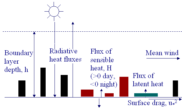
.
Urban Station Survey: http://www.mi.uni-hamburg.de/cost715/form.html
Preliminary Survey Results: http://www.mi.uni-hamburg.de/cost715/inventory.html
COST 715: http://www.dmu.dk/Atmospheric Environment/cost715.htm
Met Office home page (for Aeolius, nitrogen dioxide polynomials, Boxurb) http://www.metoffice.com/environment
Validation of a street canyon model in two cities
Environmental Monitoring and Assessment Vol 52 (1-2) pp. 255-267
Nomograms for calculating pollution within street canyons
Atmospheric Environment Vol 33 pp 1017-1036.
The intercomparison of a laser Doppler wind measuring equipment with a series of balloon cable mounted anemometers.
Digest of the Fifth Conference on Coherent Laser Radar: Technology and Application, Munich June 5-9, 1989.
Field measurements and modelling of urban meteorology in Birmingham, UK
Turbulence and Diffusion Note No 268
Meteorological Office, London Rd, Bracknell, Berkshire RG12 2SZ, UK
Field Measurements and Modelling of Surface Fluxes in Birmingham, UK.
Paper for COST 715 Working Group 2 Expert Meeting Antwerp, Belgium. To be published by EC.
Aerodynamic roughness of urban areas derived from wind observations
Boundary Layer Meteorology Vol. 89: pp. 1-24.
The COST framework for European R & D Cooperation
Eurasap newsletter August 2001 No. 42 pp. 14-23.
Field study of wind and traffic to test a street canyon pollution model.
Environmental Monitoring and Assessment, Vol 60 (2) 283-313.
Estimation of surface roughness length and displacement height from single-level sonic anemometer data
Journal of Applied Meteorology Vol 39 pp. 708-715.
A new box model to forecast urban air quality: BOXURB
Environmental Monitoring and Assessment Vol 52 pp 315 to 335.
Development of Aeolius for Street Canyon Screening
Clean Air Vol 29 (6) pp. 155-161.
National Society for Clean Air, 136 North St, Brighton BN1 1RG, UK.
Preparation of meteorological input data for urban site studies: the present practice of the UK Met Office.
Presented to COST 715 WG4 Workshop, Prague, Czech Republic, 15-16 June 2000.
Published by European Commission under COST 715 as Report EUR 19446, pp 19-34. Preparation of meteorological input data for urban site studies, ed. by M Schatzmann, J Brechler, B E A Fisher.
COST 715 Working Group 2 Expert Meeting on Surface Energy Balance in Urban Areas.
Antwerp, Belgium 12 April 2000. Meeting report.
Eurasap Newsletter No 38, June 2000, pages 12-22 ISSN-1026_2172
Boundary Layer Climates
Second Edition Reprinted 1993 Routledge
Comparison of upwind land use and roughness length measured in the urban boundary layer.
Boundary Layer Meteorology Vol. 100, pp. 469-486.
Wind input data for urban dispersion modelling.
Presented to COST 715 WG4 Workshop, Prague, Czech Republic, 15-16 June 2000.
Published by European Commission under COST 715 as Report EUR 19446, pp 77-86. Preparation of meteorological input data for urban site studies, ed. by M Schatzmann, J Brechler, B E A Fisher.
Review of atmospheric turbulence over cities
Quarterly Journal Royal Meteorological Society Vol 126, pp. 941-990.
Comparison of urban and rural wind speeds.
Presented to COST 715 WG1 Workshop, Zurich, Switzerland, 2001.
To be published by European Commission under COST 715.
Laser Doppler velocimetry applied to the measurement of local and global wind.
Wind Engineering Vol. 13 (1) pp. 1-15.
 |
||
| Scientists' Contributions | ||