
| Scientists' contributins |
OBSERVING URBAN WEATHER AND CLIMATE USING 'STANDARD' STATIONS
T. R. Oke
Department of Geography, University of British Columbia,
Vancouver, B.C. Canada V6T 1Z2
Email: toke@geog.ubc.ca
Content:
- INTRODUCTION
- SCALES AND PATTERNS OF URBAN CLIMATE
- GUIDANCE FOR LOCAL MEASUREMENTS
- ON THE PRESSING NEED FOR URBAN STATION GUIDELINES
- REFERENCES
INTRODUCTION
No environment offers more challenges to the meteorological observer than the city (1,2). Quite simply the normal protocols governing observing practice break down. Given the instruments to set up a modern weather or climate station even a seasoned meteorologist does not know where to put them to generate useful data, because almost no site conforms with the WMO rules for exposure (3,4) and in any case it's not clear what the observations are meant to characterise. At sites in most other environments the person installing the station is clear that the aim is to observe the state of the atmosphere without undue influences from the surface microclimate. This paper is about what the meteorological community should do to build a similar clarity of aims and rules for exposure when siting instruments in cities, where microclimates are everywhere. It argues for a serious attempt to develop new protocols and guidelines for those charged with installing and operating urban stations and networks.
On the whole the present state of meteorological measuring systems in cities is at best inadequate and in many cases an embarrassment. Stations are sited in bizarre locations, over widely differing surfaces, at various heights and the exposure of individual instruments commonly violates WMO rules of observing practice. When faced with these facts, those involved with installing and maintaining meteorological systems commonly shrug their shoulders and point out that it is very difficult to do better given the real diversity and constraints provided by cities and the guidelines they are given to work with. They are correct, but I argue here that it doesn't have to be this way. Establishing and running a station can be an expensive undertaking, it is therefore an enormous waste when, because of poor siting and exposure, the system underperforms or produces nonsensical information.
As I see it obvious problems arise from at least four sources:
- confusion over the purpose of observation - most meteorological stations
are established either to observe: (a) the local climate, and its trends, free
of microclimatic influences, (b) the weather free of local effects in support
of operational services; such as the air mass character as input to synoptic
forecast or specialised storm warning systems, (c) the local or regional weather
of relevance to an air quality management system, or (d) special atmospheric
features at any scale as part of research studies. The spatial and temporal
scales and focus of these objectives are very different so it may be that the
combined observational requirements cannot be met at a single site.
- settlements are dynamic - land uses change over time. Consider a site,
established in the park-like grounds of a town hall a century ago, but
subsequently has been moved from one spot to another as new buildings take
precedence. The station is now lucky to have a place next to a parking lot and
a tall building. Later it may be moved to the top of the building. Hence its
original conformity with WMO guidelines for exposure has been eroded.
- lack of understanding of micro- and urban climates - most meteorologists
are trained to focus on synoptic or regional scale objectives, few appreciate
the variations that occur at smaller scales, or the structure of city climates.
- avoidance - the complexity of the urban system and the complications associated with working within an array of tall buildings and trees causes many meteorologists to ignore cities or to turn to modelling (1).
SCALES AND PATTERNS OF URBAN CLIMATE
It cannot be over-stressed that understanding urban climates
(and observing them) is critically tied to notions of scale and boundary layer
development, as illustrated in Figure 1. At the smallest scale, that of
individual elements, each building, tree, road, etc. creates its own
microclimate. Because the city usually possesses repetitive structures, such as
building lots and streets, these elements are recombined into larger microscale
climate units such as street canyons which generate their own features, e.g.
cross-canyon vortex flow (Figure 1c). These features exist beneath roof-level,
so in analogy with plant stands this layer is called the urban canopy layer
(UCL). A larger neighbourhood comprising several street canyons plus their
intervening buildings, gardens and courtyards creates a local scale climate
which extends horizontally, but is restricted to the UCL (Figure 1b). The
influences of each element also extend above roof-level as a jumbled set of
plumes and wakes in the roughness sublayer. Due to the mixing of turbulence
these eventually merge to form a more horizontally homogeneous surface layer in
which micrometeorological theory for extensive homogeneous surfaces applies
(Figure 1b,c). If there are distinct urban terrain zones (i.e. areas of
different physical character, such as the type and density of buildings) in the
city, new internal boundary layers will form at each zone border. These are
mixed together to form the urban boundary layer (UBL) of the whole city. This
is a mesoscale phenomenon within which the air shows the integrated presence of
the city.
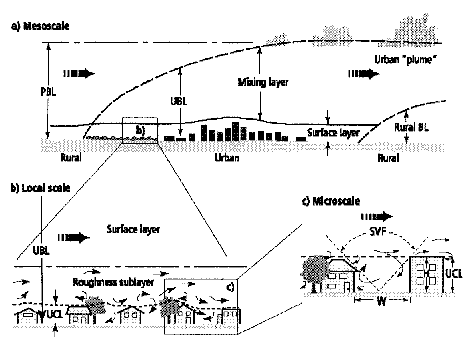
Figure 1: Idealised vertical structure of the urban atmosphere over:
- a whole city (mesoscale),
- a single urban terrain zone (local scale), and
- a single street canyon microscale). Source: (5)
The structure illustrated by Figure 1 looks complicated, but it reveals three essential scales of importance to most climate station networks:
- the micro- and local scale of the UCL - within this layer there are many
subclasses of climates, each determined by the physical character of the surface
and its immediate surroundings. The climate of a single building or single
street may be identifiable. This is the source of the nightmare for the person
who has the responsibility to locate a single station. Every surface component
(hot road, sheltering tree, shading building) threatens to swamp the readings.
However, if particularly anomalous elements can be avoided, it is often possible
to find areas of sufficiently similar character (say within one type of urban
terrain zone (UTZ); (6), and of sufficient horizontal dimensions (a circle of
about 0.5 km around the site), that a representative UCL climate station can be
established. 'Anomalous' in this context means an element which is sufficiently
close and generates a strong climatic effect so that it skews the results
relative to the local mean. This would be a local scale climate in the UCL.
- the local scale of the surface layer - in addition to observing local
climate in the UCL, as above (which is still fraught with microclimatic
difficulties) a more stable local climate response can be observed in the
surface layer. Only a restricted range of measurement heights exists (see below),
but if these limitations are met, data representative of the local scale zone
can be gathered. However, a concern may be that the results apply to a
non-standard height. Achieving a more stable spatial average comes at the price
of muting the surface effects seen in the UCL.
- the mesoscale of the UBL - if characteristics of the mixing layer in the UBL can be monitored the integrated effects of the whole city can be expressed in their contribution to the downwind mesoscale urban plume (Figure 1a).
The spatial patterns of these climates are distinct. For example, the well known change in air temperature at screen-level in the UCL, known as the urban heat island (UHI), has a steep gradient at the edge of the city, but the distribution is much flatter over most of the rest of the urban area except for relatively 'hot' and 'cool' spots in particularly densely built-up (high rise, narrow canyons) or open and/or vegetated (parks, vacant land) areas, respectively. Again, one must remember that the nature of UCL climates is dominated by the immediate surroundings, not distance from the edge or the centre. Knowledge of these patterns is essential if we wish to sample appropriately with a station network. Presumably if only a single urban station can be installed the choice is between an urban core location, where the 'maximum' urban effect occurs, or a site in the thermal plateau region, well away from edge or 'hot' or 'cool' spot effects. If multiple stations are available it must be decided if the aim is to sample all urban terrain zones or to faithfully represent the spatial pattern. If it is the latter this will require stations in all zones, but also at sites positioned to show the gradients across the city. Since the patterns in small settlements are miniature versions of those in large cities Munn (7) notes that it may take almost as many stations to portray the pattern of the UCL climates in a small city as for a large one. Similar patterns are found for humidity. It seems arguable that wind and precipitation measurements in the UCL are sufficiently open to micro-variability that it may be better to sample them only above roof-level. In this case distance from the urban-rural border, and transitions in UTZ, are more relevant because of changes in surface roughness. For radiation measurements anticipated patterns of air pollution and cloud may be significant.
GUIDANCE FOR LOCAL MEASUREMENTS
Let's look at considerations which face establishment of a standard climatological station at a site within a city. That is, we are looking at the advice provided to someone installing a station to measure air temperature, humidity, wind speed and direction, precipitation and perhaps radiation, soil temperature and evaporation.
1. Choosing the site
The question of where to locate within a city's limits, and in which UTZ, relates to the purpose of the station. Therefore decisions should be based on recognition of the spatial patterns of urban climate, and whether the station is solitary or part of a network. Once the UTZ and part of the city are chosen the next criterion is homogeneity; i.e. to locate in a part of the zone, that is reasonably representative of its surroundings. At this stage is helpful to draw up first order descriptive statistics of the area, such as the mean height of the up-standing elements (buildings and trees), and the dimensions of the spaces between them (gardens, courtyards, streets). From these measures a simple list of typical characteristics of the zone can be drawn up, perhaps in terms of normalised measures such as mean height, height to width ratio, and the ratio of built:greenspace area. This helps to develop a notion of typical exposure in the zone and provides objective scales so that potential sites can be ranked. Recognising that in the end you can only site where the opportunity/permission exists, at least you gain some idea of how fair the representation might be. What is different about this thinking, compared to that normally required, is that the essential notions of an "open" or unobstructed site are abandoned in favour of representativity. Failure to exercise this judgement leads to quite nonsensical stations. A common example is the grassed park site in the core of a large city - such a site is an anomaly for the city, in fact it doesn't take a very large vegetated park to create a climate which is thermally similar to the rural environs (8).
2. Site layout and instrument exposure
Once the site is chosen, the layout of the station, and the placement of the instruments, should be governed by existing WMO and/or national Guides where possible, but again some bounded flexibility is useful. For example, the standard short grass surface may be appropriate if the UTZ is one of open-set houses with gardens and roadside verges, but this tenet should be relaxed to accommodate artificial surfaces as the built:greenspace ratio increases. Similarly the size of the plot, and the rules regarding how many multiples of obstruction height a given instrument must be away from an obstruction, should be relaxed for certain measures. For example, if the local climate of a city core is wanted, and the typical height of buildings and trees (zH) is say 20 m, it is difficult to find a site which allows for 2zH in all directions for temperature and humidity, worse for the 4zH required for precipitation and almost impossible to get 10zH for wind. What is more important in siting the instruments is to reflect the typical dimensions of the spaces within the UCL, so as to preserve some notion of the local ratio of element height to inter-element spacing (W) - the aspect ratio (zH/W). After that the station should be centred within the space, i.e. at approximately W/2. This may be acceptable for temperature and humidity, but almost certainly not for wind or precipitation (see below). On the other hand, whilst the rules for surface type and distance from obstruction may have to be relaxed, or at least re-specified, those regarding micro-scale influences to be avoided (e.g. "excessive human traffic", "vehicle parking areas" and "where heat is exhausted by vehicles and buildings") may have to be specified much more carefully.
3. Developing guidelines for individual climatological elements
If new guidelines are to be formulated at the local scale the following may be relevant:
- temperature and humidity - normal screen-level exposure seems
appropriate, with modifications along the lines mentioned above (i.e. regarding
relaxation of surface character and distance from obstruction guidelines for
non-urban sites). Some relaxation in the recommended height may also be
necessary to avoid vandalism and human or vehicular traffic. Since the height
variation of these properties in urban canyons is relatively slight (9) this
may be acceptable. Sensor shields should include protection from sources of
infrared as well as solar radiation.
- soil temperature - few climate stations include this quantity.
Urban sites certainly present sampling difficulties for shallow depths because
of the wide variability of surface covers, but deep soil temperatures should
not be over-looked. At depths of say 0.5 m and greater the integrated heat
island of the city can be seen. Long-term trends in soil temperatures may in
fact provide better insight into urban thermal modification than the air
temperature record.
- grass-minimum temperature - few stations gather this quantity in
cities. Given that grass may be irrelevant to some parts of the city this is
understandable, but the less commonly gathered concrete minimum temperature has
interesting applications in highway meteorology and building climatology.
- wind speed and direction - UCL wind climate in the vicinity of
trees, and especially buildings and streets, is far too complex and erratic
(10) to be monitored as part of a standard network. Except in areas of small zH
(say < 4m) using the international standard height of 10 m for measurement will
not give acceptable results in cities. However, variability of wind components
decreases upwards through the roughness sublayer, and returns to values typical
of adjusted boundary layers in the surface layer ((11) and Fig. 1a,b).
Guidelines should therefore indicate that the minimum height for wind
measurements is the top of the roughness sublayer, and give methods to predict
its height. In very crude terms it is about 21/2 to 4 times zH, but it also
depends on the spacing of the roughness elements (see 12). The maximum height
of measurement is limited by the distance from the nearest upwind UTZ boundary.
Therefore fetch distance and source area dimensions are also relevant to the
choice of location within the city (see13). Given the inherent differences of
zH and building density between and within cities, wind observations may have
to be conducted at different heights at different sites. Standardisation to a
single height, say 30 m, is a simple calculation using wind profile theory. The
nature of the supporting structure is also critical to wind measurements. Even
open lattice towers distort the flow in their vicinity, so use of solid masts,
chimney stacks and booms on buildings raises serious concerns which must be
addressed in urban guidelines. We are all aware of anemometers mounted on masts
atop tall buildings; they are open to serious errors. Measures of gustiness and
the standard deviation of speed and direction may be especially important to
air quality and wind engineering applications in cities.
- precipitation - except in the most open of UTZ, observations of
precipitation in the UCL are open to many of the concerns noted for wind,
because they are subject to the chaotic airflow. In order to reduce spatial
variability in catch, consideration may have to be given to exposing rain and
snow gauges near the ground at an open space which meets or approximates the
standard exposure guidelines, even if it is not co-located with the screen.
Exposure at a similar height to the anemometer, might be contemplated but: (a)
this means the speed of catch is greater than near the ground and gauge
efficiencies are sensitive to this, (b) interception by the sides of buildings
and trees is not accounted for, and (c) even automated elevated gauges present
difficulties of maintenance. Due to drifting, snow accumulation on the ground
presents a knotty sampling problem, at least as difficult as that in forests.
The measurement of rate of precipitation, in addition to total accumulation, is
valuable especially for urban hydrologic applications.
- radiation and sunshine - measurement of incoming radiative fluxes
in the city present little problem. Exposure requirements are met by mounting
on the roof of a tall building as long as the horizon is free of obstruction.
On the other hand, measurement of upwelling and net fluxes, which require that
the sensor 'see' a representative sample of the reflecting or emitting surface,
must be made from a tall tower. Height above ground is important as a
determinant of the radiative source area. If an appropriate observation
platform is available good estimates of the radiation balance and its
components can be made. Soiling of the sensor windows by pollution necessitates
more frequent maintenance.
- evaporation - it is unlikely that meaningful observations of urban evaporation can be made using pans due to (a) the variability of winds, (b) microscale advection of heat from built surfaces which boosts evaporation beyond potential rates, and (c) it is unlikely that sensible pan coefficients exist to cover the range of possible urban surroundings.
4. Accommodating changing urban form
To be flexible the long-term observation scheme for an urban site must recognise the dynamic nature of a city's structure over time. Initial site selection should take care to avoid a site where massive change is already slated, but it may not necessarily be a good idea to be certain it will not keep pace with changes around it. If, some time after establishment, clearly unacceptable change renders the site either unable to gather sensible data or makes it anomalous for its urban terrain zone (UTZ), relocation should be considered a reasonable solution, not something to be fought without thought. Naturally potential sites for relocation should be in the same UTZ, and not subject to different local or mesoclimate controls because of different relief, proximity to water bodies, etc.). The key to this must be a strictly-adhered to protocol concerning the documentation of metadata. The metadata archive must be kept up-to-date on a reasonable schedule (say annually), and should include: exact co-ordinates, elevation, dimensions, maps and photographs of the surroundings, the form of the local horizon, surface materials, tree species, human activities and heat sources, etc. as well as the descriptions of the instruments their calibrations, height above ground, exposure, recorders and software. Such simple and inexpensive documentation is invaluable to all who subsequently wish to make use of the data.
ON THE PRESSING NEED FOR URBAN STATION GUIDELINES
Soon, more people will live in cities than anywhere else. For that reason alone meteorological services have a major responsibility to focus more on the needs of city dwellers, especially those in the rapidly urbanising tropical world. At the 12th World Meteorological Congress in Geneva, and subsequently at Habitat II in Istanbul, WMO committed itself to give high priority to the delivery of better services to cities. If that is to be meaningful, more and better urban observing stations will be required. But before National Meteorological Services invest in this infrastructure it seems imperative that the poor state of measurement practice at the stations we already have, be addressed, and that we develop guidelines for what might be called the representative urban climatological station.
This suggestion is not without precedent. As long ago as 1975 WMO circulated a questionnaire to discover the state of the art of urban observation and the need for guidelines. At the conclusion of his report Van Gysegem (1) stated: "before definite guidelines can be given more research is necessary". He suggested that topics needing more investigation included: coupling between the UCL and UBL, radiation, energy, mass and momentum exchanges and balances, quantification of the nature of urban surfaces, humidity, vertical structure of the UBL, averaging times, cities in low and high latitude climates, errors of exposure, representativity of data in specific land-use areas, measurement errors due to sensor response in the turbulent urban atmosphere, and the development of new low cost instruments and data processing systems. In the 20 years since that review and recommendation urban meteorology/climatology has made tremendous strides. Reviews of the field document that significant advances in the base of physical understanding and model development have been made (e.g. 14 - 17). Together with the improvement and automation of instrumentation in general there seems no doubt that Van Gysegem's concerns have been met. The need for guidelines has been restated. In 1982 an Expert Group recommended "there is need for WMO to define an urban climatological station as well as [to] specify [the] type and programme of observations, instrumentation, exposure and observational practice" (18). Further, in 1997 the Taskforce on TRUCE recommended the preparation of an "Urban Climate Study Guide" (19).
In some respects the measurement of air pollutants poses greater difficulties than for meteorological elements, but because this is clearly an urban question the need to devise urban guidelines for networks and sites has been greater, and progress has been better (e.g. 20,21). The meteorological community should draw upon this work.
In my view the fields of urban meteorology, climatology and hydrology now contain sufficient knowledge about the physical basis of urban atmospheres, and the technical requirements for measurement, to formulate useful and much needed addenda to the existing Guides to observing practice in their respective fields. If such a recommendation is acted upon, a significant challenge in the process of formulating guidelines will be merging the bedrock concept of standardisation, with the physical reality of the ever-changing physical nature of cities. But as Van Gysegem (1) pointed out "there is no obvious reason why there [has to] be a unique solution". Maintenance of rigorous principles of measurement is not incompatible with recognition that the system being observed changes over time.
REFERENCES
- Van Gysegem, A. 1978. Meteorological observations in urban
environment, Institut Royal Meteorologique de Belgique, Bruxelles, Publications
Serie B, No. 93.
- Oke, T.R. 1984. Methods in urban climatology. Applied Climatology,
Zurcher Geographische Schriften, 14, 19-29.
- WMO, 1983a. Guide to Meteorological Instruments and Methods of
Observation, 5th edn., WMO, Geneva.
- WMO, 1983b. Guide to Climatological Practices, 2nd edn., WMO-No.
100, WMO, Geneva.
- Oke, T.R. 1997. Urban environments. The Surface Climates of
Canada, Bailey, W.G., T.R. Oke, and W.R. Rouse (eds.), McGill-Queen's
University Press, Montreal, 303-327.
- Ellefsen, R. 1990/91. Mapping and measuring buildings in the
canopy boundary layer in ten U.S. cities. Energy Build., 15/16, 1025-1049.
- Munn, R.E. 1973. Urban meteorology: some selected topics, Bull.
Amer. Meteorol. Soc., 54, 90-93.
- Spronken-Smith, R. and T.R. Oke. 1998. The thermal regime of
urban parks in two cities with different summer climates, Int. J. Remote Sens.,
19, 2085-2104.
- Nakamura, Y. and T.R. Oke 1988. Wind, temperature and stability
conditions in an east-west oriented urban canyon, Atmos. Environ., 22, 2691-2700.
- Hosker, R.P. Jr. 1985. Flow around isolated structures and
building clusters, ASHRAE Trans, 91 (2B), 1671-92.
- Rotach, M. 1995. Profiles of turbulence statistics in and above
an urban street canyon, Atmos. Environ, 29, 1473-86
- Grimmond, C.S.B. and T.R. Oke 1999. Aerodynamic properties of
urban areas derived by analysis of urban form, J. Appl. Meteorol., 38, in press.
- Schmid, H.P. 1994. Source areas for scalars and scalar fluxes.
Bound.-Layer Meteorol., 67, 293-318.
- Oke, T.R. 1988. The urban energy balance, Phys. Geog., 12, 471-508.
- Arnfield, J. et al. 1991. Physical and boundary-layer climatology,
Phys. Geog., 12, 189-206.
- Hanna, S.R. and J.C. Chang 1992. Boundary-layer parameterizations
for applied dispersion modelling over urban areas, Bound.-Layer Meteorol., 58,
229-259.
- Cermak, J.E., et al, eds. 1995. Wind Climate in Cities, Kluwer
Academic Publishers, Dordrecht.
- WMO, 1982. Report of the Meeting of Experts on Urban and Building
Climatology, WCP - 37, WMO, Geneva.
- WMO, 1997. Report of the Meeting of the Taskforce on TRUCE,
WCASP - 40, WMO, Geneva.
- Ludwig, F.L. and J.H.S. Kealoha 1975. Selecting sites for carbon
monoxide monitoring, EPA Report 450/3-75-077, Research Triangle Park, NC, 149p.
- Munn, R.E. 1981. The Design of Air Quality Networks, Macmillan Publishers, London.
| Scientists' contributins |